Claudius Ptolemy, Geographia (Ulm, 1482)
Commentary
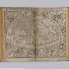
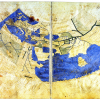
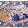
Ptolemy’s Geographia is arguably the most important book to survive from antiquity, having first been written in Greek in the second century in Alexandria. While it has been translated into both Arabic and Latin, the maps, if there were any bound with the original, did not survive the process. The major feat of the Renaissance, concerning Ptolemy, was therefore to reconstitute the maps from the description provided within Ptolemy’s text. These maps are the product of the original coordinates and data provided by Ptolemy paired with the recent advancements in cartography. The Geographia was first printed in Italy 1477 with 26 copperplate engraved maps.
This edition of the book was printed in 1482 in Ulm, Germany, after having been translated into Latin by Jacobus Angelus and edited by Nicholaus Germanus. This is the third printed edition of Geographia and the first to be printed north of the Alps. The first edition maps, of which there are 32, are woodcuts coloured with fine pigments. The blue, which features prominently, is lapis lazuli. The book was printed by Lienhart Holle who set out to produce a text unmatched in its artistry, but he grossly overestimated the demand for these books which were ultimately very expensive. His printshop went out of business shortly after selling very few copies of the Geographia. These maps were printed before the discovery of the New World in 1492, and the Americas accordingly do not feature here. The rediscovery of such texts in the Renaissance led to a revived interest in cartography and exploration.
Sources
William Poole, ‘The Ulm Ptolemy, 1482’, in Richard Foster (ed.), 50 Treasures from Winchester College (London, 2019), pp. 66–67