Ranulf Higden, Polychronicon (England, late 14th century)
External links
Related sources
Commentary
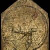
This Mappa Mundi follows a division common in medieval world maps. It features Asia in the top half, and Europe and Africa in the lower half. Maps like this has a religious purpose, and this one features Jerusalem at the centre and Paradise at the top. The Straits of Gibraltar at the base mark the edge of the known world, with the yet undiscovered Americas beyond it.
This particular map features in a compendium of world history known as the Polychronicon, originally written by Ranulf Higden (c. 1280-1364), a Benedictine monk from St Westburgh, Chester. One quarter of all Mappae Mundi come from copies of the Polychronicon such as this one, which were standard history texts until the fifteenth century. This copy is updated to include the accession of Richard II, and so was probably written shortly after 1377. The manuscript once belonged to William of Wykeham (1324-1404), the founder of Winchester College, and has been in the school since.
Sources
Liam Dunne, ‘Higden’s Polychronicon, late 14th century’, in Richard Foster (ed.), 50 Treasures from Winchester College (London, 2019), pp. 48–49.